Seven different maps that help explain Copenhagen
Copenhagen is a vibrant, multicultural city with a long history. What can maps tell us about the Danish capital? Here are a few to get you started.
Sometimes described as the “Capital of Scandinavia”, Copenhagen is Denmark’s most populous city with around 1.4 million people living in its greater urban area.
It is Denmark’s artistic and cultural powerhouse as well as the seat of its government and is known aboard for things like its work-life balance and architecture.
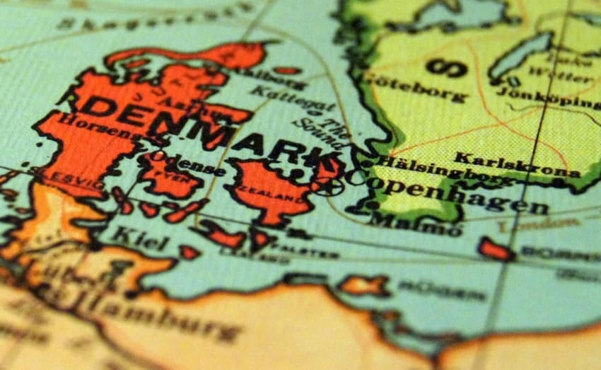
Location in Denmark
Copenhagen is about as far east as you can go in Denmark, with the exception of Baltic Sea island Bornholm.
It is surrounded by the island of Zealand and is a 45-minute rail journey from Swedish city Malmö. This is often a source of amusement for people from other parts of Denmark (particularly Jutland) who occasionally mock Copenhagen by calling it “Sweden”.
The population of Copenhagen Municipality is 600,000, with the Greater Copenhagen urban area home to around 1.4 million.
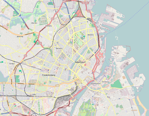
Districts
Copenhagen has several distinct districts or neighbourhoods, each with their own atmosphere and character. These include the three bro "bridge" districts located around the central lakes: hip Vesterbro, multicultural Nørrebro and family-oriented Østerbro. There's also upmarket Frederiksberg -- which is actually a municipality in its own right, and not part of Copenhagen -- the historic canal district of Christianshavn and down-to-earth Amager.
Further out, Greater Copenhagen areas like Gentofte and Hillerød are known for their affluence, Nordvest is an extension of Nørrebro and areas like Valby are suburbs which extend the city's urban sprawl.
In the very centre, the Indre By or Middelalderbyen (Inner City or Medieval City) contains the oldest and most historic streets and buildings, with sub-districts like Slotsholmen (actually an island) home of the national parliament, Christiansborg.
People who come from or have lived in Copenhagen can instinctively place each district in relation to its neighbours and know how far they are from other areas.
Maps for free, adapted by Dr. Blofeld, CC BY-SA 2.0, via Wikimedia Commons
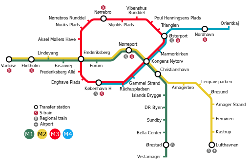
Transport links
When you think of "Copenhagen" and "Transport" in the same sentence, the first image that comes to ming might be of bicycles. While this wouldn't be wrong, the public transport coverage is extensive and efficient, particularly since two new Metro lines, the M3 and M4, were completed in 2020 (and are scheduled for extension).
KøbenhavnMetroKort+Cityringen, CC BY-SA 3.0, via Wikimedia Commons
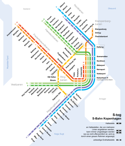
If you want to travel to the outer parts of Copenhagen, the metropolitan S-tog (S-train) service will probably get you close to your destination. The longstanding railway, almost 90 years old, consists of seven lines covering 85 stations, carrying around 350,000 passengers daily.
Creative Commons by-sa-3.0 de, CC BY-SA 3.0 DE, via Wikimedia Commons
History
Of course, Copenhagen hasn't always been the modern architecture and bustling neighbourhoods it is today. Historical maps from various points during the last two centuries give a few hints to how the city has changed.
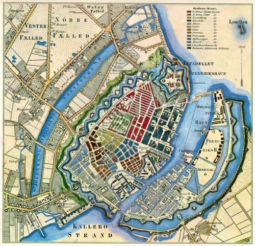
In the first of three maps below, dated 1850, you can see how the voldanlæg or lunette fortifications circled all the way around the medieval parts of the city. Today, all that remains of them is the star-shaped Citadel -- still used by the Danish military and partially open to the public -- and the paths around Christianshavn and Christiania where you can still walk on what was once the city wall.
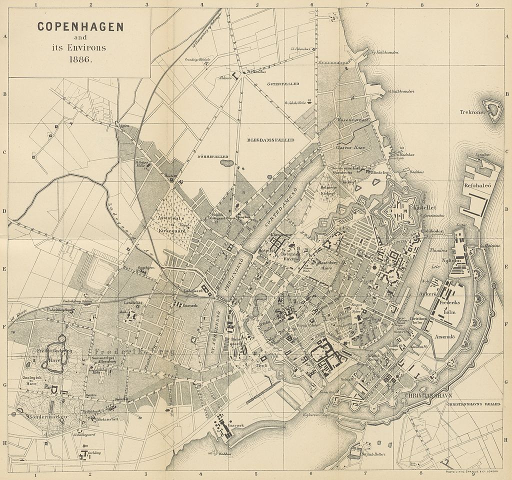
The second map, from around 35 years later, shows part of the fortifications now removed with the historical city now spilling out from its former limits. The brogade roads which now from the main streets through the outer districts can be seen, while Fælledparken park in the Østerbro area covers a much larger area than it does today.
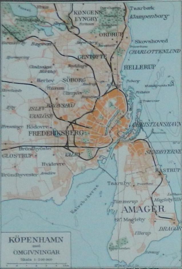
The final map, dated around 1930, shows that much of the current Greater Copenhagen area has now been developed, with the notable difference of the island of Amager, which is only around half the size it is today. Beginning in the 1930s and continuing throughout the Second World War area, a dam was built around west Amager, creating the large, flat Kalvebod Fælled area which today forms part of the extensive nature reserve Amager Nature Park.
 http://vaeggen.copenhagen.dk/media/1239, Public domain, via Wikimedia Commons
 See page for author, Public domain, via Wikimedia Commons
Undated map ca. 1930, Public domain, via Wikimedia Commons
Comments
See Also
Sometimes described as the “Capital of Scandinavia”, Copenhagen is Denmark’s most populous city with around 1.4 million people living in its greater urban area.
It is Denmark’s artistic and cultural powerhouse as well as the seat of its government and is known aboard for things like its work-life balance and architecture.
Location in Denmark
Copenhagen is about as far east as you can go in Denmark, with the exception of Baltic Sea island Bornholm.
It is surrounded by the island of Zealand and is a 45-minute rail journey from Swedish city Malmö. This is often a source of amusement for people from other parts of Denmark (particularly Jutland) who occasionally mock Copenhagen by calling it “Sweden”.
The population of Copenhagen Municipality is 600,000, with the Greater Copenhagen urban area home to around 1.4 million.
Districts
Copenhagen has several distinct districts or neighbourhoods, each with their own atmosphere and character. These include the three bro "bridge" districts located around the central lakes: hip Vesterbro, multicultural Nørrebro and family-oriented Østerbro. There's also upmarket Frederiksberg -- which is actually a municipality in its own right, and not part of Copenhagen -- the historic canal district of Christianshavn and down-to-earth Amager.
Further out, Greater Copenhagen areas like Gentofte and Hillerød are known for their affluence, Nordvest is an extension of Nørrebro and areas like Valby are suburbs which extend the city's urban sprawl.
In the very centre, the Indre By or Middelalderbyen (Inner City or Medieval City) contains the oldest and most historic streets and buildings, with sub-districts like Slotsholmen (actually an island) home of the national parliament, Christiansborg.
People who come from or have lived in Copenhagen can instinctively place each district in relation to its neighbours and know how far they are from other areas.
Transport links
When you think of "Copenhagen" and "Transport" in the same sentence, the first image that comes to ming might be of bicycles. While this wouldn't be wrong, the public transport coverage is extensive and efficient, particularly since two new Metro lines, the M3 and M4, were completed in 2020 (and are scheduled for extension).
If you want to travel to the outer parts of Copenhagen, the metropolitan S-tog (S-train) service will probably get you close to your destination. The longstanding railway, almost 90 years old, consists of seven lines covering 85 stations, carrying around 350,000 passengers daily.
History
Of course, Copenhagen hasn't always been the modern architecture and bustling neighbourhoods it is today. Historical maps from various points during the last two centuries give a few hints to how the city has changed.
In the first of three maps below, dated 1850, you can see how the voldanlæg or lunette fortifications circled all the way around the medieval parts of the city. Today, all that remains of them is the star-shaped Citadel -- still used by the Danish military and partially open to the public -- and the paths around Christianshavn and Christiania where you can still walk on what was once the city wall.
The second map, from around 35 years later, shows part of the fortifications now removed with the historical city now spilling out from its former limits. The brogade roads which now from the main streets through the outer districts can be seen, while Fælledparken park in the Østerbro area covers a much larger area than it does today.
The final map, dated around 1930, shows that much of the current Greater Copenhagen area has now been developed, with the notable difference of the island of Amager, which is only around half the size it is today. Beginning in the 1930s and continuing throughout the Second World War area, a dam was built around west Amager, creating the large, flat Kalvebod Fælled area which today forms part of the extensive nature reserve Amager Nature Park.
Join the conversation in our comments section below. Share your own views and experience and if you have a question or suggestion for our journalists then email us at [email protected].
Please keep comments civil, constructive and on topic – and make sure to read our terms of use before getting involved.
Please log in here to leave a comment.