For how long will weather disrupt transport in Denmark?
With weather conditions causing major disruption to travel in Denmark on Wednesday, how long will it take for things to return to normal?
Heavy snow and rain is falling in Denmark on Wednesday and will continue into Thursday.
Blizzards in northern and central parts of the country and rain further south from Tuesday afternoon through to Thursday, along with strong winds, are causing disruption to travel, particularly in areas with heavy snow.
READ ALSO:
- New weather warnings: Denmark braces for heavy rain and snow
- TRAVEL LATEST: Weather conditions disrupt Denmark with major rail cancellations
The good news for those travelling and commuting within Denmark is that the duration of the disruptions is likely to be relatively limited, because forecasts hold that the rain and snow will ease on Thursday.
However, it is unclear exactly when rail and other transport services will return to normal.
The heavy precipitation – which is in the form of snow in the north of the country, and rain in the south – is forecast to subside beginning on Wednesday night, returning to more normal conditions across the country by Thursday afternoon.
That does not mean transport will immediately be back to normal.
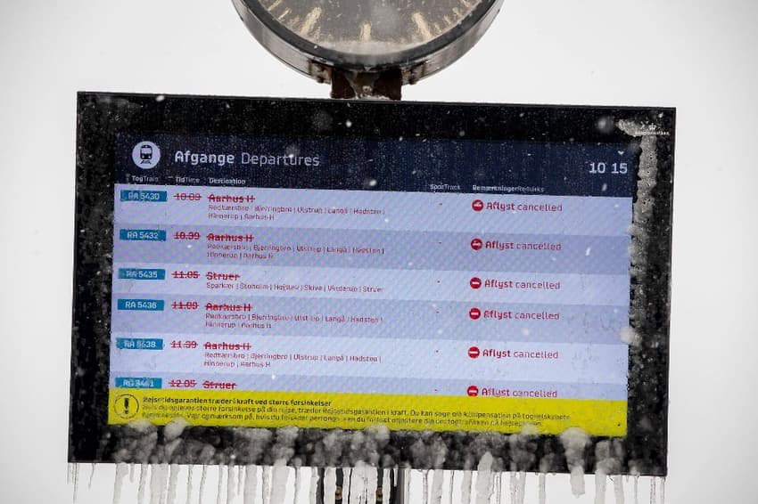
Cancellation of rail services between Aarhus and Aalborg, initially put in place until Wednesday afternoon, have now been extended by national operator DSB until Thursday.
Snow has prevented DSB trains from leaving Aarhus Central Station, DSB said on Wednesday.
The Light Rail (Letbane) in Aarhus is also suspended until at least Thursday.
A remarkable difference in temperature between the north and south of the country – from -3 degrees Celsius in the far north of Jutland to 7 degrees above zero in the south, as demonstrated by broadcaster DR – could mean that snowdrifts in the north persist after it stops snowing.
The snow is expected to spread to Copenhagen and the surrounding region on Wednesday evening.
“The snow is increasing in strength and we expect 10-15 centimetres of snow [by] Thursday morning in the capital,” broadcaster TV2’s weather forecaster Jonas Dambo said.
Most of the remaining snow is expected to fall between Aarhus and Kolding, approximately the central section of Jutland, according to TV2.
That means North Jutland, which is currently dealing with snow drifts and resulting disruptions, may have seen the peak of the snow.
North Jutland “won’t get that much more snow, but they already have problems now,” TV2’s meteorologist Jens Ringgård Christiansen said.
But in towns like Vejle and Kolding – which have so far only experienced rain and melting sleet – as much as 30 centimetres of snow could still be on the way.
In Aarhus, which has already seen deep snow, the problems could be compounded by more precipitation later on Wednesday.
Copenhageners could wake up to several centimetres of snow on Thursday.
“It will start to snow heavily [in Copenhagen] this evening, and then the snowy weather will increase during the evening and overnight hours,” Damsbo said.
“There will be a significant amount of snow. It will be going on throughout rush hour and the rest of the day,” he said.
Forecasts suggest snow until Thursday afternoon in the capital.
“That can create a lot of snow-related chaos, so it is a good idea to take care in traffic,” Damsbo told TV2.
Comments
See Also
Heavy snow and rain is falling in Denmark on Wednesday and will continue into Thursday.
Blizzards in northern and central parts of the country and rain further south from Tuesday afternoon through to Thursday, along with strong winds, are causing disruption to travel, particularly in areas with heavy snow.
READ ALSO:
- New weather warnings: Denmark braces for heavy rain and snow
- TRAVEL LATEST: Weather conditions disrupt Denmark with major rail cancellations
The good news for those travelling and commuting within Denmark is that the duration of the disruptions is likely to be relatively limited, because forecasts hold that the rain and snow will ease on Thursday.
However, it is unclear exactly when rail and other transport services will return to normal.
The heavy precipitation – which is in the form of snow in the north of the country, and rain in the south – is forecast to subside beginning on Wednesday night, returning to more normal conditions across the country by Thursday afternoon.
That does not mean transport will immediately be back to normal.
Cancellation of rail services between Aarhus and Aalborg, initially put in place until Wednesday afternoon, have now been extended by national operator DSB until Thursday.
Snow has prevented DSB trains from leaving Aarhus Central Station, DSB said on Wednesday.
The Light Rail (Letbane) in Aarhus is also suspended until at least Thursday.
A remarkable difference in temperature between the north and south of the country – from -3 degrees Celsius in the far north of Jutland to 7 degrees above zero in the south, as demonstrated by broadcaster DR – could mean that snowdrifts in the north persist after it stops snowing.
The snow is expected to spread to Copenhagen and the surrounding region on Wednesday evening.
“The snow is increasing in strength and we expect 10-15 centimetres of snow [by] Thursday morning in the capital,” broadcaster TV2’s weather forecaster Jonas Dambo said.
Most of the remaining snow is expected to fall between Aarhus and Kolding, approximately the central section of Jutland, according to TV2.
That means North Jutland, which is currently dealing with snow drifts and resulting disruptions, may have seen the peak of the snow.
North Jutland “won’t get that much more snow, but they already have problems now,” TV2’s meteorologist Jens Ringgård Christiansen said.
But in towns like Vejle and Kolding – which have so far only experienced rain and melting sleet – as much as 30 centimetres of snow could still be on the way.
In Aarhus, which has already seen deep snow, the problems could be compounded by more precipitation later on Wednesday.
Copenhageners could wake up to several centimetres of snow on Thursday.
“It will start to snow heavily [in Copenhagen] this evening, and then the snowy weather will increase during the evening and overnight hours,” Damsbo said.
“There will be a significant amount of snow. It will be going on throughout rush hour and the rest of the day,” he said.
Forecasts suggest snow until Thursday afternoon in the capital.
“That can create a lot of snow-related chaos, so it is a good idea to take care in traffic,” Damsbo told TV2.
Join the conversation in our comments section below. Share your own views and experience and if you have a question or suggestion for our journalists then email us at [email protected].
Please keep comments civil, constructive and on topic – and make sure to read our terms of use before getting involved.
Please log in here to leave a comment.