Danish forecaster warns of 'dangerous' two-metre storm surge
Denmark's state forecaster has issued a level three warning for "dangerous" storm surges south of Copenhagen and around the Little Belt strait, with sea levels as much as 2m higher than normal in some places.
According to the forecaster, sea levels will be between 1.7m and 2m higher than normal between Friday afternoon and Saturday morning in the worst affected area, which stretches from the South Funen Archipelago up into the Little Belt strait between Funen and Jutland.
The southern suburbs of Copenhagen, such as Avedore, Ishøj, and Brøndby, the south-east Zealand coast, and the coast of Lolland-Falster, will be hit by a less severe storm surge, taking sea levels to between 1.4m and 1.8m higher than normal.
"The weather situation is very serious, especially because it's going to blow for so long from an easterly direction and it is unusual for it to blow from that direction for so long," Jesper Eriksen, meteorologist on duty at DMI, told public broadcaster DR. "Because we are coming up against a stormy gale, the situation is serious."
A level-three warning is the most serious in DMI's three-point scale and signifies "very hazardous" weather, with people in affected areas advised to "be prepared that there is a high risk that weather developments may affect you and your surroundings and disrupt the functions of society."
The forecaster has also issued level 1 warnings for high winds across eastern and southern Denmark, all the way from Læsø in the Kattegat, down the east coast of Jutland, across northwest and southeast Zealand, Lolland-Falster and the South Funen Archipelago.
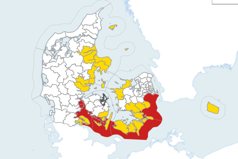
Danish forecaster has issues a level three strom surge warning for the coast of south east Denmark. Photo: DMI
Comments (1)
See Also
According to the forecaster, sea levels will be between 1.7m and 2m higher than normal between Friday afternoon and Saturday morning in the worst affected area, which stretches from the South Funen Archipelago up into the Little Belt strait between Funen and Jutland.
The southern suburbs of Copenhagen, such as Avedore, Ishøj, and Brøndby, the south-east Zealand coast, and the coast of Lolland-Falster, will be hit by a less severe storm surge, taking sea levels to between 1.4m and 1.8m higher than normal.
"The weather situation is very serious, especially because it's going to blow for so long from an easterly direction and it is unusual for it to blow from that direction for so long," Jesper Eriksen, meteorologist on duty at DMI, told public broadcaster DR. "Because we are coming up against a stormy gale, the situation is serious."
A level-three warning is the most serious in DMI's three-point scale and signifies "very hazardous" weather, with people in affected areas advised to "be prepared that there is a high risk that weather developments may affect you and your surroundings and disrupt the functions of society."
The forecaster has also issued level 1 warnings for high winds across eastern and southern Denmark, all the way from Læsø in the Kattegat, down the east coast of Jutland, across northwest and southeast Zealand, Lolland-Falster and the South Funen Archipelago.
Join the conversation in our comments section below. Share your own views and experience and if you have a question or suggestion for our journalists then email us at [email protected].
Please keep comments civil, constructive and on topic – and make sure to read our terms of use before getting involved.
Please log in here to leave a comment.